Hurricane watch posted for North Carolina coast


By ANNE BOWERS and IRENE NOLAN
By ANNE BOWERS and IRENE NOLAN
By ANNE BOWERS and IRENE NOLAN
Hurricane Earl worked its way north along the Outer Banks overnight, and heavy rains and increasing wind speeds made for a stressful night for those who tried to sleep through the storm.
However, the good news is that Hatteras and Ocracoke islands will be open to visitors tomorrow, Sept. 4, for the Labor Day weekend and beyond.
The mandatory evacuation of Ocracoke was lifted today and ferry service is expected to return to normal operations on Saturday. Highway 12 on Hatteras will be open at 7 a.m. Saturday morning.
However, motorists are advised that although access will be permitted, there may be standing water on roadways throughout the area. Proceed with caution, as it is difficult to determine the water’s depth and it can cause brake failure, loss of control, or vehicle flooding.
Earl looked to be an ocean event yesterday, and forecasters expected a high ocean storm surge. However, Earl’s highest winds were not from the northeast but from the northwest, causing sound tide to flood Hatteras and Ocracoke villages,
According to the National Weather Service in Newport, N.C., the peak wind gust was 66 mph from the northwest at about 6 a.m. this morning at Billy Mitchell Airport in Frisco. Other gusts measured were 71 in Buxton from the northwest at 6:35 a.m., 83 from the northwest in Rodanthe at 6:40 a.m., 78 in Hatteras village at 5 a.m., and 73 in Ocracoke.
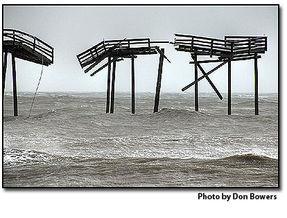
The fate of Frisco Pier was on the minds of many. The height of the storm was forecast to impact Hatteras Island at night — around 2 a.m. at high tide. Surely, the decrepit structure couldn’t have survived the wrath of Earl. Or could it?
At first light, most of Highway 12 was flooded with sound water, which severely hampered travel around the villages. It would be a while before the tide receded, making the road again passable to go to check on the pier.
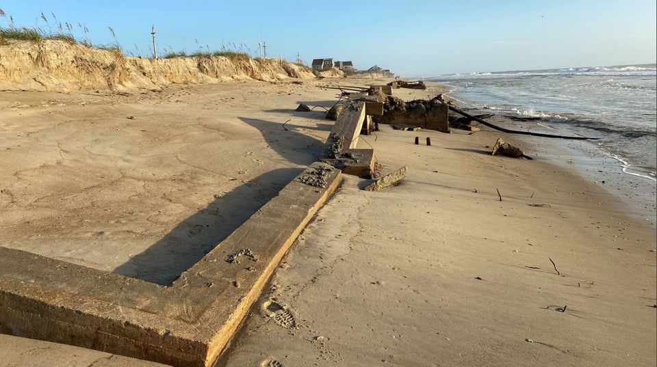
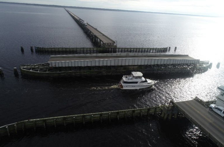
The Frisco Pier was all alone in the early morning of Friday, Sept. 3. All the well-wishers and curiosity seekers from the day before were gone.
The yellow building that sits atop the pier was clearly visible from the road. True, the pier was still standing, but now it is divided into four distinct sections. The disconnected edifice was trying to look brave in the light of what it had just endured. But even to the untrained eye, there was no bringing the fishing pier back to life.
Unlike the day before, only a few remnants of the pier littered the beach. Some boards were discovered almost a mile away where they had washed over the dune and were strewn along Highway 12 near the site of the inlet created by Hurricane Isabel in 2003.
With Frisco Pier excepted, Hurricane Earl turned out to just how we like ’em – a big ole dud. It was a non-ocean event, with most of the damage caused by soundside flooding when the winds shifted northwest as Hurricane Earl moved past the Outer Banks. Beginning around 4 a.m., the storm’s movement piled the sound waters onto the Pamlico side of the island, making the canals and creeks that run like veins throughout the villages explode with the sudden rush of unwelcome water.
In the morning, driving was slow going with the water easily too deep to safely drive through at times. The highway was littered with everything from porch furniture to impressive amounts of brand new wood, still banded together and intended for a new home under construction.
The north and northwest winds caused roof damage to the Sandbar and Grille and the Cape Hatteras Secondary School’s auditorium, both located near the sound in south Buxton.
Many homes in the villages had missing siding on the north and northwest facing sides. Several Frisco homes had over a foot of water in their sheds, garages, and ground-level rooms.
The little building that was once a tanning salon, located across from the school, had its front window and back door blown out.
In the heart of Buxton, Red Drum Shopping Center measured more than nine inches of floodwater inside their businesses.
Lighthouse View Motel had no damage to report, only the inconvenience of several inches of sound water under the motel’s units and in the parking lot.
The Haulover Area (aka Canadian Hole) received a lot of damage as the hurricane-powered sound waters raced towards the ocean dunes. The wooden boardwalk was completely washed off its foundation and pushed into the parking area. The dumpster was knocked on its side. There was considerable erosion and undermining on the bulkhead that protects the elevated parking lot above the Pamlico Sound.
Several highway signs had been twisted and wrestled to the ground by the hurricane force winds overnight.
New smells filtered into the air. The battered pine trees left the air smelling very fresh, while in other areas, the obnoxious aroma of propane leaking from overturned tanks turned noses.
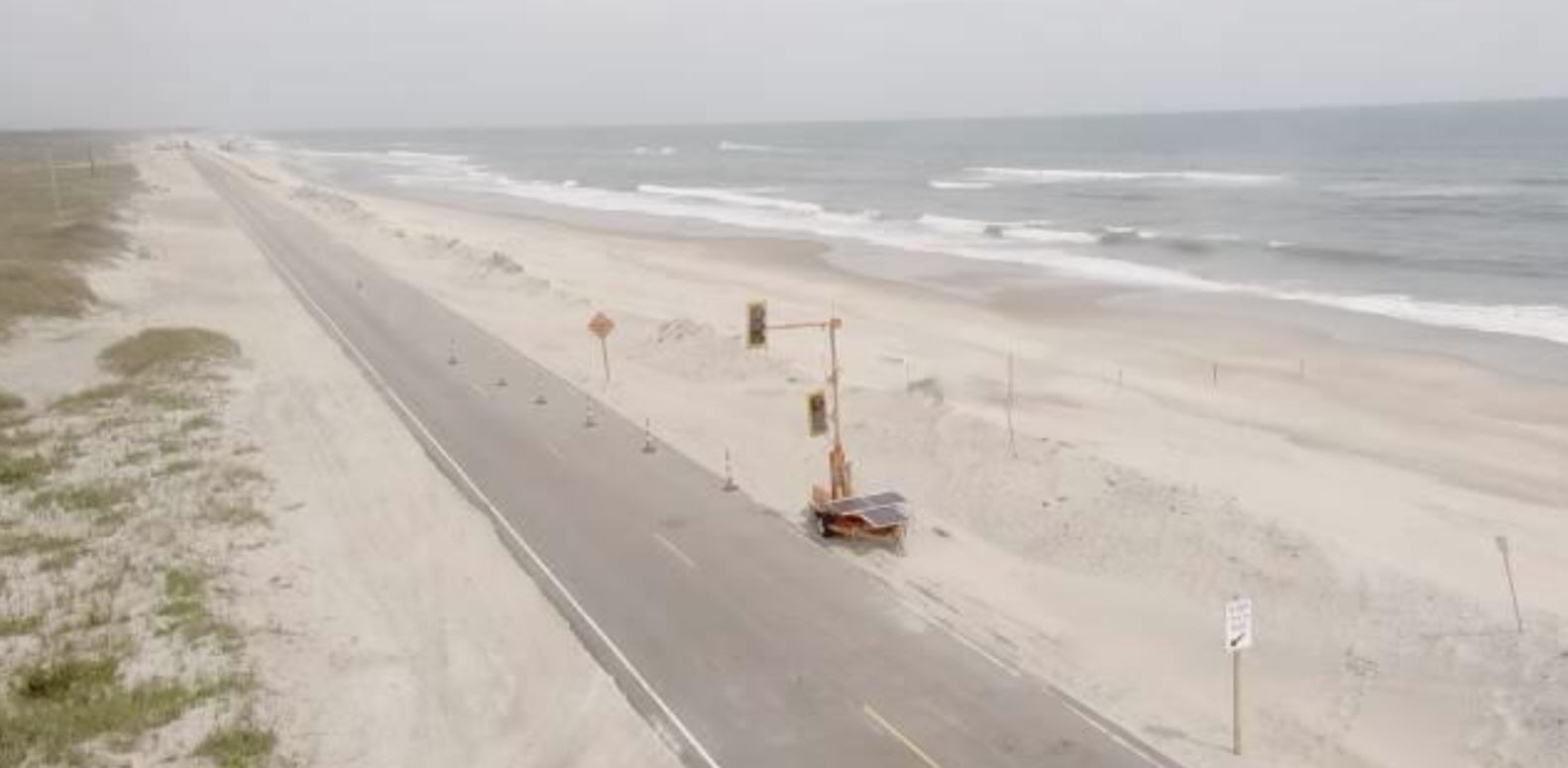
Highway 12 was closed north of Rodanthe until the road could be cleared of sand and debris overwash.
Allen Burrus of Hatteras village, vice-chairman of the Dare County Board of Commissioners, said that “Hatteras Island will remain closed until everything was back under control. Isabel taught us that lesson.”
Jerry Jennings, Division 1 engineer for the North Carolina Department of Transportation, said the hurricane event “was a whole lot better than it could have been.”
There was not structural damage, he said, to Highway 12. There was some overwash in the expected locations, he added, but there was just sand and water on the road through Hatteras and Ocracoke.
All in all, this was a hurricane the islanders could live with. Granted it was a lot a work to prepare for and it will no doubt cause a loss of business on the Labor Day weekend, the summer’s last busy weekend. But, there is very little damage and cleanup when compared to other monster storms, such as Isabel in 2003 and Emily in 1993. The recovery will be quick.
Lastly, here is a little known fact that was uncovered during the storm: The only time you can eat Spam and not die is during a hurricane. Thanks to Debbie Burrus for this little tidbit!
And one last tidbit — Commissioner Burrus got to lecture Jim Cantore of the Weather Channel – off the air.
“He called me ignorant,” Burrus said.
Cantore did a rant on the Weather Channel on Wednesday night about why there was not a mandatory evacuation on Hatteras and implied that the islanders were ignorant.
“I turned it around, and it really made him mad,” Burrus said, adding that he had seen more hurricanes in his life than Cantore had reported on.
He bet Cantore a dinner that Earl would be less than 110 mph when it passed by Hatteras. And it was – 105 mph.
Burrus expects to collect on that bet in the future.
Click Here To View Slide Show
Hurricane Earl worked its way north along the Outer Banks overnight, and heavy rains and increasing wind speeds made for a stressful night for those who tried to sleep through the storm.
However, the good news is that Hatteras and Ocracoke islands will be open to visitors tomorrow, Sept. 4, for the Labor Day weekend and beyond.
The mandatory evacuation of Ocracoke was lifted today and ferry service is expected to return to normal operations on Saturday. Highway 12 on Hatteras will be open at 7 a.m. Saturday morning.
However, motorists are advised that although access will be permitted, there may be standing water on roadways throughout the area. Proceed with caution, as it is difficult to determine the water’s depth and it can cause brake failure, loss of control, or vehicle flooding.
Earl looked to be an ocean event yesterday, and forecasters expected a high ocean storm surge. However, Earl’s highest winds were not from the northeast but from the northwest, causing sound tide to flood Hatteras and Ocracoke villages,
According to the National Weather Service in Newport, N.C., the peak wind gust was 66 mph from the northwest at about 6 a.m. this morning at Billy Mitchell Airport in Frisco. Other gusts measured were 71 in Buxton from the northwest at 6:35 a.m., 83 from the northwest in Rodanthe at 6:40 a.m., 78 in Hatteras village at 5 a.m., and 73 in Ocracoke.
The fate of Frisco Pier was on the minds of many. The height of the storm was forecast to impact Hatteras Island at night — around 2 a.m. at high tide. Surely, the decrepit structure couldn’t have survived the wrath of Earl. Or could it?
At first light, most of Highway 12 was flooded with sound water, which severely hampered travel around the villages. It would be a while before the tide receded, making the road again passable to go to check on the pier.
The Frisco Pier was all alone in the early morning of Friday, Sept. 3. All the well-wishers and curiosity seekers from the day before were gone.
The yellow building that sits atop the pier was clearly visible from the road. True, the pier was still standing, but now it is divided into four distinct sections. The disconnected edifice was trying to look brave in the light of what it had just endured. But even to the untrained eye, there was no bringing the fishing pier back to life.
Unlike the day before, only a few remnants of the pier littered the beach. Some boards were discovered almost a mile away where they had washed over the dune and were strewn along Highway 12 near the site of the inlet created by Hurricane Isabel in 2003.
With Frisco Pier excepted, Hurricane Earl turned out to just how we like ’em – a big ole dud. It was a non-ocean event, with most of the damage caused by soundside flooding when the winds shifted northwest as Hurricane Earl moved past the Outer Banks. Beginning around 4 a.m., the storm’s movement piled the sound waters onto the Pamlico side of the island, making the canals and creeks that run like veins throughout the villages explode with the sudden rush of unwelcome water.
In the morning, driving was slow going with the water easily too deep to safely drive through at times. The highway was littered with everything from porch furniture to impressive amounts of brand new wood, still banded together and intended for a new home under construction.
The north and northwest winds caused roof damage to the Sandbar and Grille and the Cape Hatteras Secondary School’s auditorium, both located near the sound in south Buxton.
Many homes in the villages had missing siding on the north and northwest facing sides. Several Frisco homes had over a foot of water in their sheds, garages, and ground-level rooms.
The little building that was once a tanning salon, located across from the school, had its front window and back door blown out.
In the heart of Buxton, Red Drum Shopping Center measured more than nine inches of floodwater inside their businesses.
Lighthouse View Motel had no damage to report, only the inconvenience of several inches of sound water under the motel’s units and in the parking lot.
The Haulover Area (aka Canadian Hole) received a lot of damage as the hurricane-powered sound waters raced towards the ocean dunes. The wooden boardwalk was completely washed off its foundation and pushed into the parking area. The dumpster was knocked on its side. There was considerable erosion and undermining on the bulkhead that protects the elevated parking lot above the Pamlico Sound.
Several highway signs had been twisted and wrestled to the ground by the hurricane force winds overnight.
New smells filtered into the air. The battered pine trees left the air smelling very fresh, while in other areas, the obnoxious aroma of propane leaking from overturned tanks turned noses.
Highway 12 was closed north of Rodanthe until the road could be cleared of sand and debris overwash.
Allen Burrus of Hatteras village, vice-chairman of the Dare County Board of Commissioners, said that “Hatteras Island will remain closed until everything was back under control. Isabel taught us that lesson.”
Jerry Jennings, Division 1 engineer for the North Carolina Department of Transportation, said the hurricane event “was a whole lot better than it could have been.”
There was not structural damage, he said, to Highway 12. There was some overwash in the expected locations, he added, but there was just sand and water on the road through Hatteras and Ocracoke.
All in all, this was a hurricane the islanders could live with. Granted it was a lot a work to prepare for and it will no doubt cause a loss of business on the Labor Day weekend, the summer’s last busy weekend. But, there is very little damage and cleanup when compared to other monster storms, such as Isabel in 2003 and Emily in 1993. The recovery will be quick.
Lastly, here is a little known fact that was uncovered during the storm: The only time you can eat Spam and not die is during a hurricane. Thanks to Debbie Burrus for this little tidbit!
And one last tidbit — Commissioner Burrus got to lecture Jim Cantore of the Weather Channel – off the air.
“He called me ignorant,” Burrus said.
Cantore did a rant on the Weather Channel on Wednesday night about why there was not a mandatory evacuation on Hatteras and implied that the islanders were ignorant.
“I turned it around, and it really made him mad,” Burrus said, adding that he had seen more hurricanes in his life than Cantore had reported on.
He bet Cantore a dinner that Earl would be less than 110 mph when it passed by Hatteras. And it was – 105 mph.
Burrus expects to collect on that bet in the future.
Click Here To View Slide Show
By IRENE NOLAN
By IRENE NOLAN
By IRENE NOLAN
The forecast track of Hurricane Earl edged closer to Hatteras and Ocracoke islands today.
At 5 p.m., the National Hurricane Center forecast the storm to pass by offshore of Cape Hatteras, but much too close for comfort.
Any slight deviation in the path could bring the storm directly over the Cape – or send it further offshore.
An approaching cold front is predicted to nudge Earl more to the north, but that has not happened yet and when it will is anyone’s guess.
Earl was a Category 3 hurricane with winds of 125 for much of the day, but regained its Category 4 strength by the 5 p.m. forecast.
Hurricane force winds extended out to 90 miles from the center and tropical storm force winds out to 200 miles.
It poses a formidable threat in terms of wind, wave action, ocean overwash, and soundside flooding as the hurricane passes north of the islands.
Forecasts now call for tropical storm force winds on the islands by late tomorrow afternoon or evening, and the National Hurricane Center said in its 5 p.m. forecast that hurricane force winds are “expected” here overnight Thursday and into Friday morning.
After midnight tomorrow night, winds are predicted at 55 to 65 knots with gusts as high as 85 knots.
Breaking waves on the beach are expected to be as high as 15 feet, with 25-foot waves just offshore.
A storm surge on the oceanside is predicted in the range of 3 feet above normal and 3 to 5 feet on the soundside as the storm passes by early Friday.
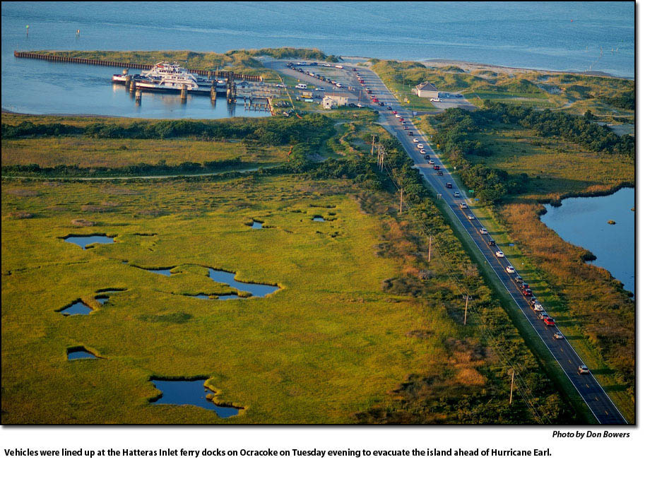
Mandatory evacuations of residents and visitors on Ocracoke began this morning at 5 a.m. and just a few hours later, Dare County announced a mandatory evacuation for visitors on Hatteras Island.
This evening, as the predicted path of the hurricane edged more to the west, Dare County announced a mandatory evacuation for Hatteras Island residents also – beginning at 6 p.m.
The forecast track of Hurricane Earl edged closer to Hatteras and Ocracoke islands today.
At 5 p.m., the National Hurricane Center forecast the storm to pass by offshore of Cape Hatteras, but much too close for comfort.
Any slight deviation in the path could bring the storm directly over the Cape – or send it further offshore.
An approaching cold front is predicted to nudge Earl more to the north, but that has not happened yet and when it will is anyone’s guess.
Earl was a Category 3 hurricane with winds of 125 for much of the day, but regained its Category 4 strength by the 5 p.m. forecast.
Hurricane force winds extended out to 90 miles from the center and tropical storm force winds out to 200 miles.
It poses a formidable threat in terms of wind, wave action, ocean overwash, and soundside flooding as the hurricane passes north of the islands.
Forecasts now call for tropical storm force winds on the islands by late tomorrow afternoon or evening, and the National Hurricane Center said in its 5 p.m. forecast that hurricane force winds are “expected” here overnight Thursday and into Friday morning.
After midnight tomorrow night, winds are predicted at 55 to 65 knots with gusts as high as 85 knots.
Breaking waves on the beach are expected to be as high as 15 feet, with 25-foot waves just offshore.
A storm surge on the oceanside is predicted in the range of 3 feet above normal and 3 to 5 feet on the soundside as the storm passes by early Friday.
Mandatory evacuations of residents and visitors on Ocracoke began this morning at 5 a.m. and just a few hours later, Dare County announced a mandatory evacuation for visitors on Hatteras Island.
This evening, as the predicted path of the hurricane edged more to the west, Dare County announced a mandatory evacuation for Hatteras Island residents also – beginning at 6 p.m.
Visitors were packing up and leaving rental cottages, motels, and campgrounds, but few residents seemed inclined to leave today.
Today was sunny and warm – a great beach day, but waves and rip currents were picking up as the day went on.
Conditions are predicted to go downhill tomorrow afternoon as rain bands, wind, and large waves from the storm come onshore.
Hurricane Earl, forecasters say, is one of the strongest hurricanes to retain its strength this far north.
The Park Service shut down campgrounds and visitor centers today, and has prohibited off-road vehicle access to the seashore as of this evening..
Also today, Gov. Bev Perdue declared a State of Emergency for North Carolina in advance of the arrival of Hurricane Earl. The governor’s order calls for all state and local agencies to cooperate in the implementation of provisions of the North Carolina Emergency Operations Plan. North Carolina is running extra ferry routes from Ocracoke Island and established an emergency shelter in Pitt County at North Pitt High School at 5659 NC Highway 11 North in Bethel, North Carolina.
All Dare County Schools will be closed on Thursday, Sept. 2, and Friday, Sept. 3. Makeup days are scheduled for Saturday, Sept. 11, and Friday, Oct. 29. All after-school activities are cancelled for Thursday and Friday, including the After-School Enrichment Program
Court sessions at the Dare County Courthouse are cancelled for Thursday and Friday. Those with cases scheduled for either of those days will receive a letter from the Court advising of a new date.
Dare County Parks and Recreation has cancelled all activities for Thursday, Friday, and Saturday.
Many other businesses and attractions on Hatteras and Ocracoke have also shut down.
On a lighter note, most islanders did not panic until late this afternoon when Jim Cantore of the Weather Channel showed up on Hatteras. He is always sent to Ground Zero in storms. Yesterday, Stephanie Abrams broadcast live from the Lighthouse Beach. Last night, Jeff Morrow was live up the beach, and Abrams returned live up the beach this morning.
Now we have Cantore here on Hatteras, and he says he is prepared to stay a few days if Highway 12 is closed – and that is almost a certainty.
FOR MORE INFORMATION
You can check the Dare County website at www.darenc.com or the Hyde County website at www.hydecountync.gov for updates on evacuations and road conditions.
You can go on the website of the local National Weather Service office in Newport, N.C., for local updates, warnings, and forecasts at http://www.erh.noaa.gov/er/mhx/
The North Carolina Department of Transportation is providing real-time information about travel conditions through its Twitter feeds. In an emergency, NCDOT immediately sends out tweets about road closures, flooding, ferry cancellations. and evacuation routes.
There are feeds for the northern coastal region and the southern coastal region and the ferry system.
A list of all 18 NCDOT Twitter feeds is available at www.ncdot.gov/travel/twitter.
Twitter is accessible on hand-held devices even if traditional telephone service and electricity are disrupted.
Valuable travel information is also available through the department’s other social media tools – Facebook, Flickr and YouTube.
By IRENE NOLAN
By IRENE NOLAN
By IRENE NOLAN
Hurricane Earl is on a path to brush by the Outer Banks late Thursday night or early Friday morning, and a hurricane watch was issued at 5 p.m. this afternoon for the entire North Carolina coast from Surf City to Duck.
The only question now is how close Earl, a strong Category 4 hurricane with winds of 135 mph this afternoon, will come to the islands.
Over the last 24 hours, the track of Earl has shifted slightly to the west with the National Hurricane Center predicting today that the storm may come within 100 miles of Cape Hatteras – or even closer.
Most weather models are in agreement that Earl will not make landfall on the Outer Banks, but the storm is still capable of doing damage to the islands.
Forecasters are calling for a possibility of tropical storm conditions on Hatteras and Ocracoke by Thursday afternoon and perhaps hurricane conditions overnight Thursday into Friday morning.
The islands are likely to see heavy surf — as high as 24 to 26 feet on the beaches Thursday night– ocean overwash that may shut down Highway 12, rain, wind, significant soundside flooding, and a high risk of rip currents.
This evening’s forecast for Hatteras and Ocracoke was for northeast winds 30 to 40 mph with gusts to 55 late Thursday and hurricane conditions possible overnight Thursday with north winds 45 to 55 mph with gusts to 75.
Islanders woke up this morning to Stephanie Abrams of the Weather Channel broadcasting live from the Lighthouse Beach in Buxton. This evening the channel’s Jeff Morrow, whose parents, Dee and Cliff Morrow, live in Buxton, was broadcasting live from the beach in Kill Devil Hills.
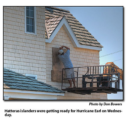
Most islanders are starting to prepare for the onslaught, as are local and state government agencies.
Dare and Hyde counties’ emergency management groups met this morning and deferred a decision on evacuations until tomorrow.
The Hyde County media release said its emergency management group will meet again this evening to review the latest forecasts and that the group anticipates “a mandatory evacuation for Ocracoke Island on Wednesday, Sept. 1, beginning at 5 a.m.”
Dare County’s Control Group will meet again early tomorrow morning, Sept. 1, and if the path of the hurricane has not shifted significantly to the east, the group will likely order a mandatory evacuation of Hatteras Island.
The National Park Service will close its facilities on the Cape Hatteras National Seashore tomorrow. The Ocracoke Visitor Center will close at noon, and the Hatteras Island, Bodie Island, Wright Brothers, and Fort Raleigh visitor centers will close at 5 p.m. The last climb to the top of the Cape Hatteras Lighthouse will be at 2 p.m., and the lighthouse will close at 3 p.m.
Also, the Park Service’s campgrounds at Ocracoke, Frisco, Cape Point, and Oregon Inlet will close at noon tomorrow.
“By Thursday,” the NPS release said, “expected ocean overwash and rough surf conditions will create unsafe conditions on seashore beaches and off-road vehicle use will be prohibited until safe conditions allow for this recreational activity.”
The North Carolina Department of Transportation is also preparing to respond to the hurricane.
NCDOT crews are stationing heavy equipment in problem areas, such as Highway 12 on Hatteras in the Mirlo Beach area, and making sure the vehicles are topped off with fuel. Also, ferries have been moved to Stumpy Point and Rodanthe in case Highway 12 through Pea Island is closed, and the emergency ferry route must be implemented.
FOR MORE INFORMATION
You can check the Dare County website at www.darenc.com or the Hyde County website at www.hydecountync.gov for updates on evacuations and road conditions.
You can go on the website of the local National Weather Service office in Newport, N.C., for local updates, warnings, and forecasts at http://www.erh.noaa.gov/er/mhx/
The North Carolina Department of Transportation is providing real-time information about travel conditions through its Twitter feeds. In an emergency, NCDOT immediately sends out tweets about road closures, flooding, ferry cancellations and evacuation routes.
There are feeds for the northern coastal region and the southern coastal region and the ferry system.
A list of all 18 NCDOT Twitter feeds is available at www.ncdot.gov/travel/twitter.
Twitter is accessible on hand-held devices even if traditional telephone service and electricity are disrupted.
Valuable travel information is also available through the department’s other social media tools – Facebook, Flickr and YouTube.
Subject
Name
(required, will not be published)
(required, will not be published)
City :
State :
Your Comments:
May be posted on the Letters to the Editor page at the discretion of the editor.
May be posted on the Letters to the Editor page at the discretion of the editor.
May be posted on the Letters to the Editor page at the discretion of the editor.
May be posted on the Letters to the Editor page at the discretion of the editor.